
The following day, around ten, we left for the trail. We went for the Pinhoti side first, since there was more water on the Cave Creek side where we would end up camping. I reset the trip on my GPS just after the trailhead to Pinhoti connector. Before long, we were underway.


Dad went with us to Hernandez Peak, then turned back. He followed a service road back to civilization. Hernandez Peak was a pretty good climb up to a rocky peak only a couple hundred feet shorter than Cheaha. as we were walking along, the cliffs began to loom before us.

This is me at the bottom. The trail seems as though it's going to go around the cliffs, but then it turns and goes straight up them through a slightly lower pass.


At the summit of Hernandez we stopped to rest a moment as the climb was tiring.


Dad left us there, escaping before any pictures of him could be taken. Clarence and I continued on down the Pinhoti.

The terrain became more rocky as it wound around the summit of McDill point.

Soon, the views became more impressive.

We stopped at McDill point for lunch.


The trail looped back around the other side of McDill point, passing through some more boulders.

A few miles later, we came to the connector to the Cave Creek trail.

It jumped across the summit of a mountain.


After hiking most of the way to Cave Creek, we took a short detour off the trail to get some water. It was a difficult slide down, going under brush and around trees. We did eventually make it to the bottom, where we got water out of a crystal clear, bubbling mountain stream.


We walked up the a ways, until we decided to make the hundred vertical foot climb out of the valley.
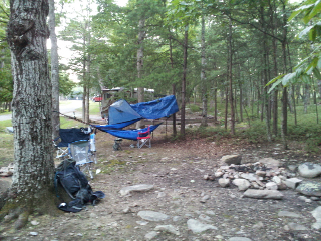
We followed the trail a little ways down, and then diverted off of it to the campsite that Dad and I camped at a few months ago.

While it looks different now that its summer, It was still somewhat familiar.
With rain on the horizon, and thunder rolling closer, we decided to eat. I had bought some Mountain House freeze-dried teriyaki chicken at Dick's before we left, and so I boiled some water in a emptied percolator pot.

It actually tasted pretty good, I wasn't expecting much, but it smelled quite good. There was the occasional dehydrated crunch, but good overall. I used my Pocketrocket again, still worked well.


The rain started not long after that, and didn't end until after dark. I ended up going to bed about eight, and waking up about eight the next morning. I did wake up a time or two during the night, being cold even though it was august. Some sort of insulation under you is good, even in summer.
The next morning, I awoke to sunlight shining through the trees, and the sound of birds singing and bees buzzing. It was still cool at that time, though it was beginning to get muggy.

There were two dry spots on the ground where our rain tarps covered. Clarence's was enormous, it covered what seemed like a square mile. In order to try to get out before it got hot again, we headed out early, right after breakfast.

The trail continued on, winding throughout the forest. The miles ticked by, and we got more tired. This side of the trail had adequate water, so that was nice.

My sawyer filter served me well on this trip.

The trail continued on, perched above the horse creek valley. Before long, we passed the large sinkhole from the last hiking trip, followed by the power line cut, and then the trailhead junction.

As you can see, the we ended up at 11.22 miles. I'm pretty sure that 5.7 mph top speed is from when we were sliding down the hill, but I don't know. Our average speed was pretty good though, 2.2 mph.
It was a really fun trip. I'm tired, sore, and itchy, but it was worth it. The forest is full of life this time of year, and many people miss out on it. It was somewhat uncomfortable, but it was still fun.

In the end, the (literally) hundreds of bug bites were well worth the hike. It was great, and I would do it again tomorrow. In fact, I may yet do that.
No comments:
Post a Comment